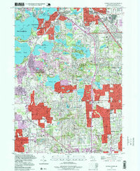
1997 Map of Pontiac South
USGS Topo · Published 1999About this map
The glacial lake district of Oakland County is on full display in this late-1990s survey, dominated by large water bodies like Cass Lake, Orchard Lake, and Pine Lake. The landscape reflects a transition from early lakeside recreational settlements to affluent suburban expansion, centered around Orchard Lake Village and Keego Harbor. Notable local landmarks include Apple Island and the historic grounds of St Marys College, situated along the eastern shore of Orchard Lake.
Find a feature on this map
90 named features on this map. Tap any name to fly to it.
Don’t see what you’re looking for? This feature index may not catch every label — zoom into the map to look around manually.
Map Details
Editions of this 1997 Pontiac South Map
This is the sole edition of this map. No revisions or reprints were ever made.
Other maps of this area

1905 · Wayne
USGS Topo · 1:62,500

1905 · Detroit
USGS Topo · 1:62,500

1907 · Pontiac
USGS Topo · 1:62,500

1908 · Rochester
USGS Topo · 1:62,500

1912 · Wayne
USGS Topo · 1:62,500

1918 · Detroit
USGS Topo · 1:62,500

1924 · Detroit
USGS Topo · 1:62,500

1934 · Detroit
USGS Topo · 1:62,500

1936 · Birmingham
USGS Topo · 1:31,680

1936 · Clarkston
USGS Topo · 1:31,680