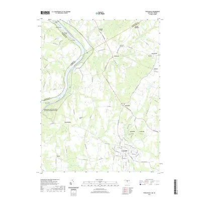
2019 Map of Poolesville
USGS Topo · Published 2019About this map
The Potomac River corridor dominates the landscape of this 2019 survey, where the river serves as a natural boundary between Maryland and Virginia. The northern reach of the Chesapeake and Ohio Canal National Historical Park follows the river's curve, passing several large islands including Nolands Island and Mason Island. Inland, the rural character of Montgomery County is anchored by historic settlements like Poolesville and Beallsville, which are connected by a network of longstanding routes such as Whites Ferry Rd and Darnestown Rd. Evidence of the area's social and religious history is found at the Mount Pleasant Methodist Church Cem and the Saint Marys Catholic Cem. The CSX Transportation line cuts through the northeast, serving the community of Dickerson near the confluence where the Monocacy River joins the Potomac.
Find a feature on this map
95 named features on this map. Tap any name to fly to it.
Don’t see what you’re looking for? This feature index may not catch every label — zoom into the map to look around manually.
Map Details
Editions of this 2019 Poolesville Map
This is the sole edition of this map. No revisions or reprints were ever made.
Other maps of this area

1884 · Harpers Ferry
USGS Topo · 1:125,000

1891 · Harpers Ferry
USGS Topo · 1:125,000

1893 · Frederick
USGS Topo · 1:125,000

1893 · Harpers Ferry
USGS Topo · 1:125,000

1894 · Frederick
USGS Topo · 1:125,000

1908 · Middletown
USGS Topo · 1:48,000

1908 · Seneca
USGS Topo · 1:62,500

1908 · Ijamsville
USGS Topo · 1:62,500

1909 · Ijamsville
USGS Topo · 1:62,500

1910 · Antietam
USGS Topo · 1:62,500