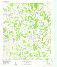
1959 Map of Poolville
USGS Topo · Published 1960About this map
The Clear Fork Trinity River winds through the heart of northern Parker County, defining a landscape shaped by a series of water management projects and early petroleum exploration. The 1950s era of rural modernization is evident in the numerous numbered reservoirs, from Res No 4 down to Res No 15, which dot the drainages of Cottonwood Creek and Gourdneck Creek. The small community of Poolville sits near the western edge, while Agnes serves as a secondary focal point to the east.
Find a feature on this map
41 named features on this map. Tap any name to fly to it.
Don’t see what you’re looking for? This feature index may not catch every label — zoom into the map to look around manually.
Map Details
Editions of this 1959 Poolville Map
2 editions found
Other maps of this area

1891 · Weatherford
USGS Topo · 1:125,000

1893 · Weatherford
USGS Topo · 1:125,000

1930 · Boyd
USGS Topo · 1:62,500

1932 · Springtown
USGS Topo · 1:62,500

1954 · Dallas
USGS Topo · 1:250,000

1954 · Sherman
USGS Topo · 1:250,000

1958 · Dallas
USGS Topo · 1:250,000

1958 · Sherman
USGS Topo · 1:250,000

1958 · Springtown
USGS Topo · 1:24,000
1959 · Lake Weatherford
USGS Topo · 1:24,000