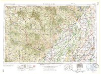
1959 Map of Poplar Bluff
USGS Topo · Published 1959About this map
The Ozark Escarpment serves as a dramatic geologic divide on this sheet, separating the rugged Salem Plateau from the flat lowlands of the Mississippi Embayment. In the late 1950s, this region was defined by its relationship with water and timber, with the Mark Twain National Forest blanketing the west and the sprawling waters of Lake Wappapello anchoring the northeast. The Black River and Current River meander through the center, while the eastern edge is dominated by the complex drainage networks of the Little River and the St. Francis River.
Find a feature on this map
135 named features on this map. Tap any name to fly to it.
Don’t see what you’re looking for? This feature index may not catch every label — zoom into the map to look around manually.
Map Details
Editions of this 1959 Poplar Bluff Map
This is the sole edition of this map. No revisions or reprints were ever made.
Other maps of this area

1890 · Batesville
USGS Topo · 1:125,000

1890 · Mountain Home
USGS Topo · 1:125,000

1891 · Mountain Home
USGS Topo · 1:125,000

1891 · Batesville
USGS Topo · 1:125,000
1892 · Mountain View
USGS Topo · 1:125,000
1894 · Mountain View
USGS Topo · 1:125,000

1894 · Mountain Home
USGS Topo · 1:125,000
1915 · Eminence
USGS Topo · 1:62,500
1917 · Eminence
USGS Topo · 1:62,500
1928 · Cardareva
USGS Topo · 1:62,500