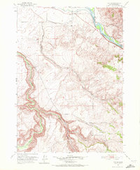
1951 Map of Poplar
USGS Topo · Published 1972About this map
Poplar serves as the primary landmark in this eastern Idaho landscape, situated where the high desert terrain meets the fertile irrigation systems of the Snake River valley. The map documents an intricate network of water management essential to mid-century agriculture, featuring the Riley Ditch and various canals that divert water from the main river channel. Beyond the irrigated flats, the topography is defined by sharp elevation changes and numerous seasonal watercourses, including Birch Creek and Willow Creek, which carve deep paths through the high country of Bonneville County. Natural water sources like Stinking Spring and Mud Spring are specifically noted, highlighting their importance for livestock or local navigation in an otherwise arid environment. The map captures the area just after World War II, showing the established rural road system and the remote character of Croyden Gulch before later regional developments.
Find a feature on this map
15 named features on this map. Tap any name to fly to it.
Don’t see what you’re looking for? This feature index may not catch every label — zoom into the map to look around manually.
Map Details
Editions of this 1951 Poplar Map
4 editions found
Other maps of this area

1924 · Hell Creek
USGS Topo · 1:62,500

1924 · Ammon
USGS Topo · 1:62,500

1926 · Hell Creek
USGS Topo · 1:62,500

1950 · Ririe
USGS Topo · 1:24,000

1950 · Rigby
USGS Topo · 1:62,500

1950 · Rigby SE
USGS Topo · 1:24,000

1951 · Rigby SE
USGS Topo · 1:24,000

1951 · Poplar
USGS Topo · 1:24,000

1951 · Hawley Gulch
USGS Topo · 1:24,000

1951 · Heise
USGS Topo · 1:24,000