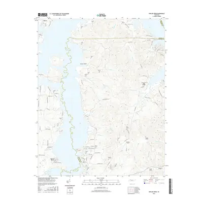
2016 Map of Poplar Creek
USGS Topo · Published 2016About this map
Kentucky Lake dominates the western edge of this 2016 survey, where the waters of the Tennessee River meet the rolling hills of Henry and Benton counties. The landscape is defined by the numerous inlets and hollows created by the reservoir, including McSwain Hollow and the drainage of Poplar Cr. The area is notably dense with small family and community burial grounds such as Liberty Cem, Mount Zion Cem, and Pleasant Ridge Cem, reflecting a long-established rural population. Residential growth is evident at Lakeview Manor in the southwest, while the small settlement of Faxon sits near the southern boundary. Infrastructure like the Big Sandy Airpark and the road network around Lick Creek shows the modern layout of these lakeside communities. The map provides a detailed view of the transition from wooded ridges to the expansive shoreline of the lake.
Find a feature on this map
99 named features on this map. Tap any name to fly to it.
Don’t see what you’re looking for? This feature index may not catch every label — zoom into the map to look around manually.
Map Details
Editions of this 2016 Poplar Creek Map
This is the sole edition of this map. No revisions or reprints were ever made.
Other maps of this area

1936 · Poplar Creek
USGS Topo · 1:24,000

1936 · Buchanan
USGS Topo · 1:24,000

1936 · McKinnon
USGS Topo · 1:24,000

1936 · Big Sandy
USGS Topo · 1:24,000

1936 · Centerville Landing
USGS Topo · 1:24,000

1936 · Harmon Creek
USGS Topo · 1:24,000

1936 · Standing Rock
USGS Topo · 1:24,000

1936 · Manleyville
USGS Topo · 1:24,000

1936 · Springville
USGS Topo · 1:24,000

1938 · Springville
USGS Topo · 1:24,000