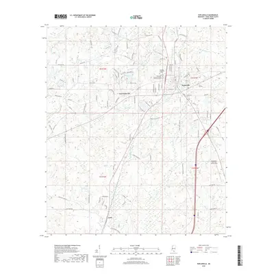
2018 Map of Poplarville
USGS Topo · Published 2018About this map
Poplarville serves as the focal point of this Pearl River County survey, showcasing the town's layout alongside West Poplarville and the settlement of Derby to the south. The landscape is defined by a dense network of watercourses, including Juniper Cr, Beaverdam Cr, and Cypress Cr, which carve through the undulating terrain of southern Mississippi. Significant educational and infrastructure landmarks are prominent, notably the Pearl River Community College campus and the Poplarville-Pearl River County Airport.
Find a feature on this map
107 named features on this map. Tap any name to fly to it.
Don’t see what you’re looking for? This feature index may not catch every label — zoom into the map to look around manually.
Map Details
Editions of this 2018 Poplarville Map
This is the sole edition of this map. No revisions or reprints were ever made.
Other maps of this area

1953 · Mobile
USGS Topo · 1:250,000

1955 · Savannah
USGS Topo · 1:62,500

1957 · Mobile
USGS Topo · 1:250,000

1958 · Carnes
USGS Topo · 1:62,500

1958 · Picayune
USGS Topo · 1:62,500

1959 · Poplarville
USGS Topo · 1:62,500

1960 · Mobile
USGS Topo · 1:250,000

1963 · Mobile
USGS Topo · 1:250,000

1965 · Mobile
USGS Topo · 1:250,000
1982 · Savannah
USGS Topo · 1:24,000