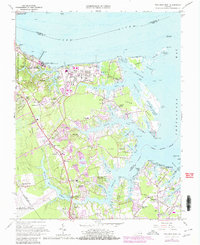
1965 Map of Poquoson West
USGS Topo · Published 1980About this map
Colonial National Historical Park occupies the western edge of this coastal survey, where Battle Trenches and the Moore House sit near the mouth of the York River. This area of the Virginia Peninsula showcases a landscape shaped by military presence and maritime industry during the mid-1960s, with a massive Tank Farm on Goodwin Neck and the U S Naval Supply Center dominating the northern shoreline. Inland, the transition from rural crossroads like Hornsbyville and Grafton to modern residential developments is evident in the appearing subdivisions of Holly Hills and Piney Point Estates. Along the intricate shoreline of Chesapeake Bay, the map traces the complex network of necks and coves, from Fish Neck to Pasture Neck, where small settlements like Seaford and Dandy are established among the tidal marshes.
Find a feature on this map
98 named features on this map. Tap any name to fly to it.
Don’t see what you’re looking for? This feature index may not catch every label — zoom into the map to look around manually.
Map Details
Editions of this 1965 Poquoson West Map
3 editions found
Other maps of this area

1906 · Williamsburg
USGS Topo · 1:62,500

1907 · Yorktown
USGS Topo · 1:62,500

1907 · Hampton
USGS Topo · 1:62,500

1916 · Mathews
USGS Topo · 1:62,500

1917 · Mathews
USGS Topo · 1:62,500

1943 · Yorktown
USGS Topo · 1:62,500

1943 · Richmond
USGS Topo · 1:250,000

1944 · Hampton
USGS Topo · 1:24,000

1944 · Yorktown
USGS Topo · 1:24,000

1944 · Messick
USGS Topo · 1:24,000