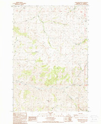
1988 Map of Porcupine Butte
USGS Topo · Published 1988About this map
Porcupine Butte rises as a central landmark in this high-desert landscape of north-central Oregon, where the drainage systems of Pine Creek and West Fork Butte Creek have carved a complex network of canyons and gulches. The area's ranching history is anchored by the Knox Ranch and several isolated improvements, such as the Stone Cabin located near the head of a canyon. This 1988 survey captures a terrain defined by water access and rough transit, marked by scattered water sources like Coates Spring and Starr Spring. Evidence of early industrial and transit activity remains in the form of an Old Mill Can and a Gravel Pit, while a lone Cem stands as a quiet record of early inhabitants. The map's extensive system of 4wd trails illustrates how the rugged topography of Chichester Gulch and Robinson Canyon dictated movement across this corner of Wheeler County.
Find a feature on this map
80 named features on this map. Tap any name to fly to it.
Don’t see what you’re looking for? This feature index may not catch every label — zoom into the map to look around manually.
Map Details
Editions of this 1988 Porcupine Butte Map
This is the sole edition of this map. No revisions or reprints were ever made.
Other maps of this area

1916 · Condon
USGS Topo · 1:125,000

1926 · Mitchell
USGS Topo · 1:125,000

1953 · The Dalles
USGS Topo · 1:250,000

1955 · Bend
USGS Topo · 1:250,000

1956 · The Dalles
USGS Topo · 1:250,000

1957 · Bend
USGS Topo · 1:250,000

1957 · The Dalles
USGS Topo · 1:250,000

1958 · Bend
USGS Topo · 1:250,000

1966 · Kinzua
USGS Topo · 1:62,500

1966 · Clarno
USGS Topo · 1:62,500