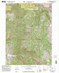
1998 Map of Porcupine Reservoir
USGS Topo · Published 2001About this map
Hardware Ranch Wildlife Management Area anchors the northeastern corner of this terrain, where the Hardware Ranch and Cooks Cabin mark the human footprint in an otherwise high-elevation landscape. The topography is dominated by the Bear River Range, a complex network of canyons including Hyrum Canyon, Paradise Canyon, and South Cottonwood Canyon. In the southwest, the Porcupine Reservoir collects the waters of the West Fork Little Bear River, while the East Fork Little Bear River cuts through the southern reaches of the Cache National Forest. The map documents critical infrastructure through the high country, such as the Great Western Trail and a pipeline corridor that traverses the mountain ridges. Distinctive landmarks like Mineral Point and Porcupine Ridge define the vertical relief of this northern Utah watershed.
Find a feature on this map
34 named features on this map. Tap any name to fly to it.
Don’t see what you’re looking for? This feature index may not catch every label — zoom into the map to look around manually.
Map Details
Editions of this 1998 Porcupine Reservoir Map
This is the sole edition of this map. No revisions or reprints were ever made.
Other maps of this area

1914 · Logan
USGS Topo · 1:125,000

1916 · Logan
USGS Topo · 1:125,000

1949 · Boulter Mts
USGS Topo · 1:24,000

1954 · Ogden
USGS Topo · 1:250,000

1955 · Paradise
USGS Topo · 1:24,000

1955 · James Peak
USGS Topo · 1:24,000

1958 · Ogden
USGS Topo · 1:250,000

1960 · Ogden
USGS Topo · 1:250,000

1961 · Logan
USGS Topo · 1:24,000

1964 · Monte Cristo PK
USGS Topo · 1:24,000