1918 Map of Porcupine Valley
USGS Topo · Published 1949About this map
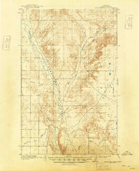
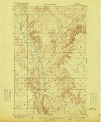
Porcupine Valley in Valley County serves as the central focal point for this landscape surveyed just before the end of the First World War. The drainage systems of Porcupine Creek and the East Fork dictate the region's topography, carving deep into the surrounding plateaus. This era in eastern Montana shows a territory organized by the General Land Office, where topography was often defined more by water and erosion than by town infrastructure. Local landmarks like Enright Coulee and Union Coulee break the plains, while the named area of Sargent and the waters of Cherry Creek provide reference points for early twentieth-century land claims. The intricate contour lines illustrate the stark relief between the valley floors and the high breaks typical of this part of the Missouri River watershed.
Find a feature on this map
10 named features on this map. Tap any name to fly to it.
Don’t see what you’re looking for? This feature index may not catch every label — zoom into the map to look around manually.
Map Details
Editions of this 1918 Porcupine Valley Map
2 editions found
Other maps of this area

1914 · Nashua
USGS Topo · 1:62,500

1915 · Frazer
USGS Topo · 1:62,500

1915 · Spring Creek
USGS Topo · 1:62,500

1916 · Nashua
USGS Topo · 1:62,500
1918 · Porcupine Valley
USGS Topo · 1:62,500

1919 · Boundary
USGS Topo · 1:125,000

1943 · Glasgow
USGS Topo · 1:125,000

1954 · Glasgow
USGS Topo · 1:250,000

1957 · Glasgow
USGS Topo · 1:250,000

1958 · Glasgow
USGS Topo · 1:250,000