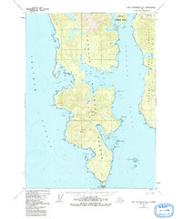
1948 Map of Port Alexander A-1
USGS Topo · Published 1992About this map
Kuiu Island dominates this mid-century survey of the Alexander Archipelago, showing a landscape defined by deep fjords and maritime navigation. The southern tip of the island is anchored by Cape Decision, where a prominent Lighthouse and Heliport serve as critical markers for vessels transitioning from the open waters of the Chatham Strait into the protected reaches of the Affleck Canal. The interior remains largely undeveloped within the Tongass National Forest, characterized by significant peaks like Mount McArthur and Mount Howard. The coastline is heavily indented with numerous inlets including Kell Bay, Table Bay, and the sheltered waters of Port McArthur, offering insight into the natural harbors that have historically supported the region's fishing and maritime activities.
Find a feature on this map
24 named features on this map. Tap any name to fly to it.
Don’t see what you’re looking for? This feature index may not catch every label — zoom into the map to look around manually.
Map Details
Editions of this 1948 Port Alexander A-1 Map
3 editions found
Other maps of this area

1948 · Petersburg A-6
USGS Topo · 1:63,360

1948 · Port Alexander A-1
USGS Topo · 1:63,360

1948 · Petersburg B-6
USGS Topo · 1:63,360

1948 · Port Alexander B-1
USGS Topo · 1:63,360

1948 · Port Alexander A-2
USGS Topo · 1:63,360
1948 · Craig D-7 and D-8
USGS Topo · 1:63,360

1948 · Port Alexander B-2
USGS Topo · 1:63,360

1951 · Craig D-6
USGS Topo · 1:63,360

1951 · Port Alexander
USGS Topo · 1:250,000

1951 · Port Alexander B-2
USGS Topo · 1:63,360