
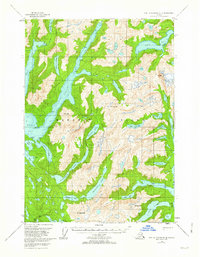
1951 Map of Port Alexander C-3
USGS Topo · Published 1959About this map
Baranof Island is defined by its dramatic glacial carved topography and deep fjords in this mid-century survey of the Tongass National Forest. The interior is dominated by a chain of significant freshwater bodies including Plotnikof Lake, Rezanof Lake, and Deer Lake, which drain into the saltwater inlets of the Gulf of Alaska. Coastal features like Whale Bay and its Great Arm, along with Deep Cove and Gut Bay, illustrate the intricate maritime geography of the Alexander Archipelago. This sheet, based on late 1940s aerial photography and older maritime surveys, names several high peaks like Mt Muravief and Mt Yanovski, marking the steep elevation changes from sea level to over 3,000 feet. The presence of isolated cabins along the water's edge suggests the area's importance for local trapping, fishing, or forestry during the early statehood era.
Find a feature on this map
36 named features on this map. Tap any name to fly to it.
Don’t see what you’re looking for? This feature index may not catch every label — zoom into the map to look around manually.
Map Details
Editions of this 1951 Port Alexander C-3 Map
2 editions found
Other maps of this area

1948 · Port Alexander B-2
USGS Topo · 1:63,360

1951 · Port Alexander C-4
USGS Topo · 1:63,360

1951 · Port Alexander D-4
USGS Topo · 1:63,360

1951 · Port Alexander C-2
USGS Topo · 1:63,360

1951 · Port Alexander B-3 and B-4
USGS Topo · 1:63,360

1951 · Port Alexander D-3
USGS Topo · 1:63,360

1951 · Port Alexander
USGS Topo · 1:250,000

1951 · Port Alexander D-2
USGS Topo · 1:63,360

1951 · Port Alexander B-2
USGS Topo · 1:63,360

1952 · Port Alexander
USGS Topo · 1:250,000