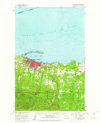
1961 Map of Port Angeles
USGS Topo · Published 1962About this map
Port Angeles serves as the focal point for this coastal survey, where the deep-water Port Angeles Harbor is protected by the distinctive curve of Ediz Hook. Along this natural breakwater sits a Coast Guard Station, while the city itself reveals its mid-century industrial and transport footprint, including the Milwaukee Road rail lines and the Olympic Memorial Hospital. The landscape transitions quickly from the urban grid into the rising timber of The Foothills and the northern boundary of Olympic National Park.
Find a feature on this map
77 named features on this map. Tap any name to fly to it.
Don’t see what you’re looking for? This feature index may not catch every label — zoom into the map to look around manually.
Map Details
Editions of this 1961 Port Angeles Map
3 editions found
Other maps of this area

1918 · Port Angeles
USGS Topo · 1:62,500

1919 · Port Crescent
USGS Topo · 1:62,500

1935 · Mount Olympus
USGS Topo · 1:62,500

1938 · Mt Constance
USGS Topo · 1:125,000

1938 · Dungeness
USGS Topo · 1:62,500

1939 · Dungeness
USGS Topo · 1:62,500

1941 · Port Angeles
USGS Topo · 1:62,500

1942 · Mount Olympus
USGS Topo · 1:62,500

1944 · Mt. Angeles
USGS Topo · 1:62,500

1946 · Mt. Angeles
USGS Topo · 1:62,500