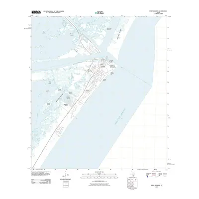
2010 Map of Port Aransas
USGS Topo · Published 2010About this map
Port Aransas sits at the gateway of the Texas coast, centered on the northern tip of Mustang Island where it meets the shipping channel and Corpus Christi Bay. This 2010 survey illustrates a landscape defined by maritime infrastructure and leisure, from the research facilities at the University of Texas Marine Science Institute to the recreational hubs at the Port Aransas City Marina and Horace Caldwell Pier. Across the channel, the Aransas Pass Lighthouse stands on Harbor Island, a stark landmark amidst the vast marshy expanses of the East Flats and Pelone Island. The map records the coastal development of Mustang Beach and Holiday Beach, documenting the shoreline as it existed just before the turn of the decade.
Find a feature on this map
29 named features on this map. Tap any name to fly to it.
Don’t see what you’re looking for? This feature index may not catch every label — zoom into the map to look around manually.
Map Details
Editions of this 2010 Port Aransas Map
This is the sole edition of this map. No revisions or reprints were ever made.
Other maps of this area

1925 · Aransas Pass
USGS Topo · 1:62,500

1950 · Corpus Christi
USGS Topo · 1:250,000

1951 · Crane Islands NW
USGS Topo · 1:24,000

1951 · Allyns Bight
USGS Topo · 1:24,000

1951 · Crane Islands
USGS Topo · 1:62,500

1954 · Aransas Pass
USGS Topo · 1:24,000

1954 · Port Ingleside
USGS Topo · 1:24,000

1954 · Estes
USGS Topo · 1:24,000
1954 · Port Aransas
USGS Topo · 1:24,000

1954 · Aransas Pass
USGS Topo · 1:62,500