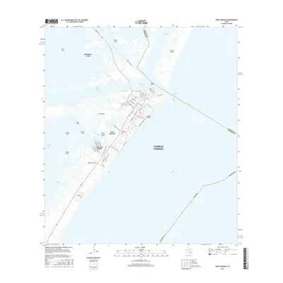
2016 Map of Port Aransas
USGS Topo · Published 2016About this map
Mustang Island and Harbor Island anchor this coastal survey, detailing the intricate marine and residential landscape where the Corpus Christi Channel meets the Gulf of Mexico. The street grid of Port Aransas is shown in detail, featuring local landmarks such as the Royal Palm Cem and the Mustang Beach Airport. This 2014-2015 data reflects the modern geography of the barrier islands, including the residential developments at Holiday Beach and Mustang Beach. To the north, across the Aransas Channel, the industrial and natural features of the flats and islands stand in contrast to the developed shoreline. Geographers can trace the tidal complexities through Turtle Cove, Flato Cut, and the expansive East Flats, which characterize the dynamic environment of the Texas coastal bend.
Find a feature on this map
70 named features on this map. Tap any name to fly to it.
Don’t see what you’re looking for? This feature index may not catch every label — zoom into the map to look around manually.
Map Details
Editions of this 2016 Port Aransas Map
This is the sole edition of this map. No revisions or reprints were ever made.
Other maps of this area

1925 · Aransas Pass
USGS Topo · 1:62,500

1950 · Corpus Christi
USGS Topo · 1:250,000

1951 · Crane Islands NW
USGS Topo · 1:24,000

1951 · Allyns Bight
USGS Topo · 1:24,000

1951 · Crane Islands
USGS Topo · 1:62,500

1954 · Aransas Pass
USGS Topo · 1:24,000

1954 · Port Ingleside
USGS Topo · 1:24,000

1954 · Estes
USGS Topo · 1:24,000
1954 · Port Aransas
USGS Topo · 1:24,000

1954 · Aransas Pass
USGS Topo · 1:62,500