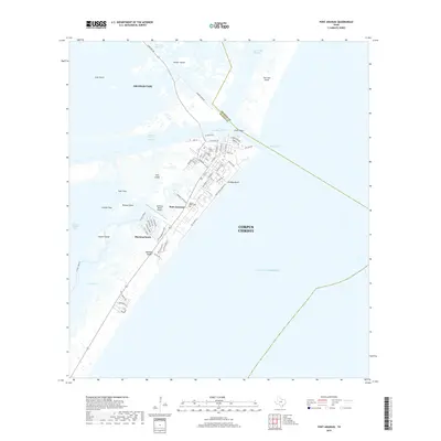
2019 Map of Port Aransas
USGS Topo · Published 2019About this map
Mustang Island and its primary settlement of Port Aransas serve as the focal point for this coastal survey of the Texas Bend region. The landscape is defined by a complex network of barrier islands and navigable waterways, including the Corpus Christi Channel and Lydia Ann Channel, which facilitate transit between Corpus Christi Bay and the Gulf of Mexico. The town's grid is dense with local thoroughfares such as W Cotter Ave and S Alister St, leading toward development at Holiday Beach and Mustang Beach. On the periphery, features like Harbor Island and the Mustang Beach Airport highlight the area's role as a maritime and transportation hub. Local history is grounded in sites like the Royal Palm Cem and the natural divisions of East Flats and Salt Island.
Find a feature on this map
74 named features on this map. Tap any name to fly to it.
Don’t see what you’re looking for? This feature index may not catch every label — zoom into the map to look around manually.
Map Details
Editions of this 2019 Port Aransas Map
This is the sole edition of this map. No revisions or reprints were ever made.
Other maps of this area

1925 · Aransas Pass
USGS Topo · 1:62,500

1950 · Corpus Christi
USGS Topo · 1:250,000

1951 · Crane Islands NW
USGS Topo · 1:24,000

1951 · Allyns Bight
USGS Topo · 1:24,000

1951 · Crane Islands
USGS Topo · 1:62,500

1954 · Aransas Pass
USGS Topo · 1:24,000

1954 · Port Ingleside
USGS Topo · 1:24,000

1954 · Estes
USGS Topo · 1:24,000
1954 · Port Aransas
USGS Topo · 1:24,000

1954 · Aransas Pass
USGS Topo · 1:62,500