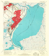
1957 Map of Port Arthur
USGS Topo · Published 1967About this map
Industrial developments along the Port Arthur Canal and Neches River define this mid-century portrait of the Texas Gulf Coast. Massive clusters of Oil Refinery plants and Tank Farm facilities dominate the landscape around Port Arthur, Port Neches, and Groves, illustrating the region's mid-century economic engine. In contrast to the heavy industry of the western shore, the eastern reaches of Sabine Lake transition into the marshlands of the Sabine National Wildlife Refuge in Louisiana. Local social geography is detailed through numerous neighborhood schools such as Woodworth Sch and De Queen Sch, and recreational landmarks like the Port Arthur Pleasure Pier. The map traces the intricate waterway network of the Intracoastal Waterway and various bayous, including Taylor Bayou and Salt Bayou, which supported both the petrochemical industry and local maritime commerce.
Find a feature on this map
93 named features on this map. Tap any name to fly to it.
Don’t see what you’re looking for? This feature index may not catch every label — zoom into the map to look around manually.
Map Details
Editions of this 1957 Port Arthur Map
2 editions found
Other maps of this area

1926 · Terry
USGS Topo · 1:24,000

1926 · Vidor
USGS Topo · 1:24,000

1932 · Sabine Pass NE
USGS Topo · 1:31,680

1932 · Beaumont
USGS Topo · 1:62,500

1932 · Orange
USGS Topo · 1:62,500

1932 · Port Arthur NE
USGS Topo · 1:31,680

1934 · Johnsons Bayou
USGS Topo · 1:24,000

1934 · Greens Bayou
USGS Topo · 1:24,000

1935 · Greens Bayou
USGS Topo · 1:31,680

1935 · Johnsons Bayou
USGS Topo · 1:31,680