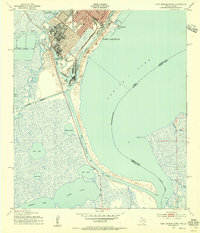
1943 Map of Port Arthur South
USGS Topo · Published 1955About this map
Industrial maritime infrastructure and expansive coastal wetlands define this 1943 survey of the Texas-Louisiana border. Port Arthur stands as the primary hub, its street grid and rail lines from the Southern Pacific and Kansas City Southern converging on the deep-water Turning Basin. This map captures the critical junction of the Neches River and the Port Arthur Canal, highlighting a sophisticated network of waterways including the Intracoastal Waterway that facilitated mid-century Gulf Coast shipping.
Find a feature on this map
25 named features on this map. Tap any name to fly to it.
Don’t see what you’re looking for? This feature index may not catch every label — zoom into the map to look around manually.
Map Details
Editions of this 1943 Port Arthur South Map
2 editions found
Other maps of this area

1932 · Sabine Pass NE
USGS Topo · 1:31,680

1932 · Port Arthur NE
USGS Topo · 1:31,680

1943 · West of Johnson Bayou
USGS Topo · 1:24,000

1943 · West of Greens Bayou
USGS Topo · 1:24,000

1943 · Port Arthur North
USGS Topo · 1:24,000

1943 · Port Arthur South
USGS Topo · 1:24,000

1944 · Sabine Pass
USGS Topo · 1:31,680

1944 · Texas Point
USGS Topo · 1:31,680
1946 · Port Arthur NE
USGS Topo · 1:31,680
1946 · Sabine Pass NE
USGS Topo · 1:31,680