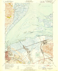
1951 Map of Port Chicago
USGS Topo · Published 1951About this map
Industrial developments and tidal marshlands dominate this mid-century coastal landscape where Suisun Bay meets the Carquinez Strait. The era's logistical footprint is evident in the expansive Naval Reservation at Port Chicago and the significant Oil Refinery infrastructure near Avon (Associated PO). These facilities are linked by a dense rail network, including the Southern Pacific and Atchison Topeka and Santa Fe lines, which navigate the low-lying terrain alongside Pacheco Creek.
Find a feature on this map
57 named features on this map. Tap any name to fly to it.
Don’t see what you’re looking for? This feature index may not catch every label — zoom into the map to look around manually.
Map Details
Editions of this 1951 Port Chicago Map
2 editions found
Other maps of this area

1896 · Carquinez Strait
USGS Topo · 1:62,500

1896 · Mt. Diablo
USGS Topo · 1:62,500

1897 · Concord
USGS Topo · 1:62,500

1898 · Karquines
USGS Topo · 1:62,500

1898 · Mt. Diablo
USGS Topo · 1:62,500

1901 · Karquines
USGS Topo · 1:62,500

1902 · Napa
USGS Topo · 1:125,000

1907 · Antioch
USGS Topo · 1:62,500

1908 · Antioch
USGS Topo · 1:62,500

1915 · Concord
USGS Topo · 1:62,500