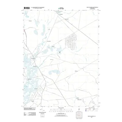
2011 Map of Port Elizabeth
USGS Topo · Published 2011About this map
The Maurice River dominates the western landscape of this coastal New Jersey corridor, anchoring a string of maritime-influenced settlements including Port Elizabeth, Mauricetown, and Leesburg. This 2011 survey documents a region where water and sand define the economic and physical layout, with the Manumuskin River winding through the center toward the interior. The map reveals an intricate network of smaller watercourses like Muskee Creek and West Creek, many tied to historic industry as seen at Jones Mill and Hoffmans Mill. Evidence of historical water management is clear at the Cumberland Pond Dam in the north. Inland, the terrain rises slightly at Muskee Hill, while the road network connects smaller hubs such as Dorchester and Bricksboro to the surrounding woodland and wetlands. These roads, such as Port Elizabeth Cumberland Rd and Estell Manor Rd, follow the natural contours of the river valleys.
Find a feature on this map
86 named features on this map. Tap any name to fly to it.
Don’t see what you’re looking for? This feature index may not catch every label — zoom into the map to look around manually.
Map Details
Editions of this 2011 Port Elizabeth Map
This is the sole edition of this map. No revisions or reprints were ever made.
Other maps of this area

1888 · Dennisville
USGS Topo · 1:62,500

1890 · Tuckahoe
USGS Topo · 1:62,500

1890 · Maurice Cove
USGS Topo · 1:62,500

1890 · Bridgeton
USGS Topo · 1:62,500

1891 · Maurice Cove
USGS Topo · 1:62,500

1893 · Tuckahoe
USGS Topo · 1:62,500

1894 · Dennisville
USGS Topo · 1:62,500

1894 · Bridgeton
USGS Topo · 1:62,500

1899 · Vineland
USGS Topo · 1:125,000

1918 · Tuckahoe
USGS Topo · 1:62,500
Featured Places
- Millville, NJ
- Upper Township, NJ
- Maurice River Township, NJ
- Commercial Township, NJ
- Leesburg, Maurice River Township