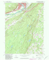
1969 Map of Port Jervis South
USGS Topo · Published 1984About this map
Tristates sits at the convergence of the Neversink River and the Delaware River, marking the point where New York, New Jersey, and Pennsylvania meet. This 1969 field-checked survey highlights the diverse landscape of the tri-state area, from the developed streets of Port Jervis and Matamoras to the high ridges of Kittatinny Mountain. The terrain is characterized by steep elevation changes, particularly within High Point State Park where Lake Marcia and the summit reside. Local infrastructure is well-defined, featuring the Conrail rail lines, New Jersey State Highway 23, and the winding Appalachian Trail. For those tracing family history, several prominent landmarks are noted, including St Marys Cemetery, Laurel Grove Cemetery, and St Francis Hospital. The map also preserves the paths of early transportation routes like the Old Deckertown Turnpike and the Greenville Turnpike.
Find a feature on this map
60 named features on this map. Tap any name to fly to it.
Don’t see what you’re looking for? This feature index may not catch every label — zoom into the map to look around manually.
Map Details
Editions of this 1969 Port Jervis South Map
Other maps of this area

1888 · Franklin
USGS Topo · 1:62,500

1891 · Wallpack
USGS Topo · 1:62,500

1893 · Wallpack
USGS Topo · 1:62,500

1894 · Franklin
USGS Topo · 1:62,500

1897 · Franklin
USGS Topo · 1:62,500

1903 · Franklin Furnace
USGS Topo · 1:62,500

1906 · Port Jervis
USGS Topo · 1:62,500

1908 · Port Jervis
USGS Topo · 1:62,500

1913 · Milford
USGS Topo · 1:62,500

1915 · Milford
USGS Topo · 1:62,500