1984 Map of Port Lavaca
USGS Topo · Published 1984About this map
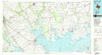
Matagorda Bay and its complex network of inlets define this coastal Texas landscape, where the Lavaca River and Navidad River meet the gulf. The regional economy of the mid-1980s is clearly etched into the terrain, characterized by numerous oil fields and a heavy reliance on maritime and rail transport. Significant infrastructure including the Victoria Barge Canal and the Intracoastal Waterway facilitates industrial movement alongside established railroad lines like the Southern Pacific and Missouri Pacific. Inland, the map captures the transition from the marshes around Green Lake and Powderhorn Lake to the agricultural and energy-producing lands surrounding Victoria and Edna. Small coastal communities such as Port Alto and Magnolia Beach sit adjacent to prominent points and reefs, reflecting the area's deep connection to the water.
Find a feature on this map
122 named features on this map. Tap any name to fly to it.
Don’t see what you’re looking for? This feature index may not catch every label — zoom into the map to look around manually.
Map Details
Editions of this 1984 Port Lavaca Map
This is the sole edition of this map. No revisions or reprints were ever made.
Historical Maps of Victoria Through Time
1 maps found