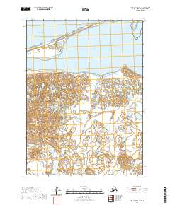
2020 Map of Port Moller D-4 NW
USGS Topo · Published 2020About this map
Bristol Bay defines the northern coastline of this remote coastal landscape, where the tides meet a complex system of ponds and marshes. The terrain is characterized by low-lying wetlands punctuated by localized high points such as Trap House Hills and Big Hill. To the south, the Sapsuk River meanders through the landscape, serving as a primary hydrological artery for the region. A solitary road, labeled Easy Street, traces the thin barrier beach along the bay, providing the only identified terrestrial transport route in an area otherwise dominated by water and shifting sands. This survey captures a moment in the modern era where human infrastructure remains minimal, restricted primarily to the coastal fringe while the interior remains an intricate network of unnamed water bodies.
Find a feature on this map
11 named features on this map. Tap any name to fly to it.
Don’t see what you’re looking for? This feature index may not catch every label — zoom into the map to look around manually.
Map Details
Editions of this 2020 Port Moller D-4 NW Map
This is the sole edition of this map. No revisions or reprints were ever made.
Other maps of this area

1953 · Port Moller
USGS Topo · 1:250,000

1963 · Port Moller D-5
USGS Topo · 1:63,360
1963 · Port Moller D-4
USGS Topo · 1:63,360

1988 · Port Moller
USGS Topo · 1:250,000
2020 · Port Moller D-4 OE N SW
USGS Topo · 1:25,000
2020 · Port Moller D-4 SE
USGS Topo · 1:25,000
2020 · Port Moller D-4 OE N SE
USGS Topo · 1:25,000
2020 · Port Moller D-4 NE
USGS Topo · 1:25,000
2020 · Port Moller D-4 SW
USGS Topo · 1:25,000
2020 · Port Moller D-5 SE
USGS Topo · 1:25,000