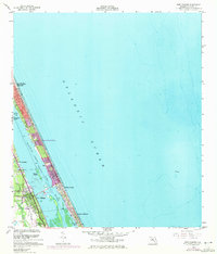
1956 Map of Port Orange
USGS Topo · Published 1972About this map
The Halifax River and the Intracoastal Waterway define the coastal geography of this Volusia County corridor, separating the mainland from the barrier island developments. Urban expansion is noted across several municipalities, including South Daytona, Port Orange, and the beachside community of Daytona Beach Shores. The landscape is a mix of residential growth and established infrastructure, featuring the Florida East Coast railway running parallel to the coast and the Reed Canal cutting through the mainland toward the river. Local landmarks such as the Drive-in Theater and Woodland Cem provide specific points of interest for local history researchers. Along the Atlantic coast, the map traces the shoreline from Daytona Beach south to Wilbur-by-the-Sea, capturing the transition from early mid-century settlement to the burgeoning suburbanization of the 1970s.
Find a feature on this map
18 named features on this map. Tap any name to fly to it.
Don’t see what you’re looking for? This feature index may not catch every label — zoom into the map to look around manually.
Map Details
Editions of this 1956 Port Orange Map
4 editions found
Other maps of this area

1937 · Port Orange
USGS Topo · 1:48,000

1937 · Ormond
USGS Topo · 1:48,000

1943 · Port Orange
USGS Topo · 1:62,500

1944 · Ormond
USGS Topo · 1:62,500

1944 · Port Orange
USGS Topo · 1:62,500

1952 · Samsula
USGS Topo · 1:24,000

1952 · Daytona Beach
USGS Topo · 1:24,000

1954 · Daytona Beach
USGS Topo · 1:250,000

1956 · Port Orange
USGS Topo · 1:24,000

1956 · New Smyrna Beach
USGS Topo · 1:24,000
Featured Places
- Daytona Beach, FL
- Daytona Beach Shores, FL
- Port Orange, FL
- Halifax Estates, Daytona Beach Shores
- Wilbur-by-the-Sea, FL