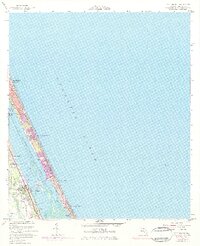
1956 Map of Port Orange
USGS Topo · Published 1971About this map
Halifax River divides the coastal barrier from the Florida mainland, serving as a corridor for the Intracostal Waterway. On the peninsula, the 1970s expansion of Daytona Beach Shores and Wilbur-by-the-Sea is evident through purple-tinted urban updates, showing a mid-century shift toward dense oceanfront development. To the west, the Florida East Coast railway runs parallel to the shore, passing through Port Orange and the southern edge of Daytona Beach. The landscape transitions from the urban grid of South Daytona to the more open wetlands near Pelican Island. Notable landmarks from this era include a Drive-in Theater and the Woodland Cem, reflecting a period when automotive culture and established local settlements defined the Volusia County coastline.
Find a feature on this map
20 named features on this map. Tap any name to fly to it.
Don’t see what you’re looking for? This feature index may not catch every label — zoom into the map to look around manually.
Map Details
Editions of this 1956 Port Orange Map
4 editions found
Other maps of this area

1937 · Port Orange
USGS Topo · 1:48,000

1937 · Ormond
USGS Topo · 1:48,000

1943 · Port Orange
USGS Topo · 1:62,500

1944 · Ormond
USGS Topo · 1:62,500

1944 · Port Orange
USGS Topo · 1:62,500

1952 · Samsula
USGS Topo · 1:24,000

1952 · Daytona Beach
USGS Topo · 1:24,000

1954 · Daytona Beach
USGS Topo · 1:250,000

1956 · Port Orange
USGS Topo · 1:24,000

1956 · New Smyrna Beach
USGS Topo · 1:24,000
Featured Places
- Daytona Beach, FL
- Daytona Beach Shores, FL
- Port Orange, FL
- Halifax Estates, Daytona Beach Shores
- Wilbur-by-the-Sea, FL