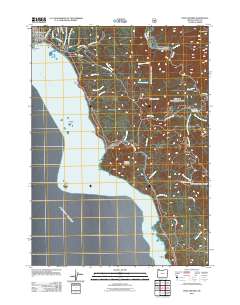
2011 Map of Port Orford
USGS Topo · Published 2011About this map
Port Orford anchors this coastal survey, where the town's historical geography is defined by a series of prominent headlands including Fort Point, Graveyard Point, and the well-known Battle Rock. This maritime landscape reflects a community shaped by its proximity to the Pacific Ocean, with inland development following old routes such as Old Mill Rd and Cemetery Loop. The topography rises sharply from the shore toward the heights of China Mountain and Humbug Mountain, creating a confined corridor for coastal transit.
Find a feature on this map
43 named features on this map. Tap any name to fly to it.
Don’t see what you’re looking for? This feature index may not catch every label — zoom into the map to look around manually.
Map Details
Editions of this 2011 Port Orford Map
This is the sole edition of this map. No revisions or reprints were ever made.
Other maps of this area

1899 · Port Orford
USGS Topo · 1:125,000

1903 · Port Orford
USGS Topo · 1:125,000

1954 · Coos Bay
USGS Topo · 1:250,000

1954 · Port Orford
USGS Topo · 1:62,500

1954 · Cape Blanco
USGS Topo · 1:62,500

1954 · Langlois
USGS Topo · 1:62,500

1958 · Coos Bay
USGS Topo · 1:250,000

1962 · Coos Bay
USGS Topo · 1:250,000
1986 · Father Mountain
USGS Topo · 1:24,000
1986 · Ophir
USGS Topo · 1:24,000