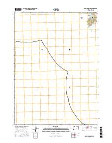
2017 Map of Port Orford OE W
USGS Topo · Published 2017About this map
Port Orford serves as the focal point of this coastal survey, where the town's grid meets the Pacific shoreline at the southern edge of Agate Beach. This specific map captures the intricate maritime geography of the Curry County coast, dominated by the prominent landform known as The Heads. The coastal interface is defined by a series of named inlets and formations, including Nellies Cove, Tichenor Cove, and the dramatic Hells Gate. Local street names like California St, 12th St, and King St ground the residential area in the landscape. Beyond the immediate coastline, offshore features like Tichenor Rock and Klooqueh Rock indicate the complex bathymetry of the region, while the boundary for t33s r15w provides the essential Public Land Survey System framework for local property research.
Find a feature on this map
16 named features on this map. Tap any name to fly to it.
Don’t see what you’re looking for? This feature index may not catch every label — zoom into the map to look around manually.
Map Details
Editions of this 2017 Port Orford OE W Map
This is the sole edition of this map. No revisions or reprints were ever made.
Other maps of this area

1899 · Port Orford
USGS Topo · 1:125,000

1903 · Port Orford
USGS Topo · 1:125,000

1954 · Coos Bay
USGS Topo · 1:250,000

1954 · Port Orford
USGS Topo · 1:62,500

1954 · Cape Blanco
USGS Topo · 1:62,500

1954 · Langlois
USGS Topo · 1:62,500

1958 · Coos Bay
USGS Topo · 1:250,000

1962 · Coos Bay
USGS Topo · 1:250,000
1986 · Ophir
USGS Topo · 1:24,000
1986 · Cape Blanco
USGS Topo · 1:24,000