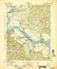
1942 Map of Port Royal
USGS Topo · Published 1942About this map
The Rappahannock River winds through this 1942 landscape, defining the historic boundary between Caroline and King George counties. This wartime survey captures the region just as the A P Hill Military Reservation was established, occupying the southwestern portion of the map with its specialized road network. The crossing at Port Royal serves as the central hub, where the James Madison Memorial Bridge links the town to Port Conway on the northern bank.
Find a feature on this map
28 named features on this map. Tap any name to fly to it.
Don’t see what you’re looking for? This feature index may not catch every label — zoom into the map to look around manually.
Map Details
Editions of this 1942 Port Royal Map
This is the sole edition of this map. No revisions or reprints were ever made.
Other maps of this area

1889 · Fredericksburg
USGS Topo · 1:125,000

1892 · Fredericksburg
USGS Topo · 1:125,000

1894 · Fredericksburg
USGS Topo · 1:125,000

1926 · Stafford
USGS Topo · 1:62,500

1931 · Stafford
USGS Topo · 1:62,500

1942 · Bowling Green
USGS Topo · 1:31,680

1942 · Upper Zion
USGS Topo · 1:31,680
1942 · Occupacia
USGS Topo · 1:31,680

1942 · Rollins Fork
USGS Topo · 1:31,680
1942 · Rappahannock Academy
USGS Topo · 1:31,680