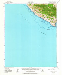
1951 Map of Port San Luis
USGS Topo · Published 1964About this map
Port San Luis anchors the southern edge of this coastal survey, where the maritime landscape of San Luis Bay meets the dramatic rising slopes of the San Luis Range. At the point, a Lighthouse stands as a vital navigational aid above the hazardous offshore features including Lone Black Rock and Santa Rosa Reef. The inland terrain is defined by complex drainage systems such as Wild Cherry Canyon and See Canyon, while high points like Saddle Pk and Bald Knob dominate the northern skyline. A single Mine indicates the area's geological and industrial activity during the mid-20th century, located among the steep ridgelines. The coastal stretch between Whalers Bay and Coon Creek remains largely undeveloped, preserving the original land grants and natural shoreline as they existed prior to late-century expansion.
Find a feature on this map
26 named features on this map. Tap any name to fly to it.
Don’t see what you’re looking for? This feature index may not catch every label — zoom into the map to look around manually.
Map Details
Editions of this 1951 Port San Luis Map
3 editions found
Other maps of this area

1897 · Port Harford
USGS Topo · 1:62,500

1897 · San Luis Obispo
USGS Topo · 1:62,500

1897 · Cayucos
USGS Topo · 1:62,500

1897 · Arroyo Grande
USGS Topo · 1:62,500

1900 · San Luis
USGS Topo · 1:125,000

1905 · Guadalupe
USGS Topo · 1:125,000

1937 · Cayucos
USGS Topo · 1:62,500

1941 · Port San Luis
USGS Topo · 1:62,500

1942 · Guadalupe
USGS Topo · 1:125,000

1942 · San Luis Obispo
USGS Topo · 1:62,500