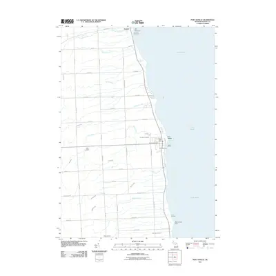
2011 Map of Port Sanilac
USGS Topo · Published 2011About this map
The village of Port Sanilac serves as a prominent maritime anchor along the Michigan shoreline, defined by its active Sanilac Marina and the sentinel Port Sanilac Light. This coastal landscape is marked by a series of parallel creeks flowing eastward into Lake Huron, including Liens Creek, Herron Creek, and McKenzie Creek. Further north, the settlement of Forester sits near the mouth of Forester Creek, reflecting the region's historical reliance on the lake for transport and trade. The interior grid is heavily focused on local history and genealogy, containing several significant burial sites such as Saint Marys Cemetery, Port Sanilac Cemetery, and the more southern Saint John Cemetery. The presence of Camp Ozanam and the Lake Huron Campground underscores the area's modern identity as a destination for lakeside recreation.
Find a feature on this map
34 named features on this map. Tap any name to fly to it.
Don’t see what you’re looking for? This feature index may not catch every label — zoom into the map to look around manually.
Map Details
Editions of this 2011 Port Sanilac Map
This is the sole edition of this map. No revisions or reprints were ever made.
Other maps of this area

1954 · Flint
USGS Topo · 1:250,000

1958 · Flint
USGS Topo · 1:250,000

1963 · Croswell
USGS Topo · 1:24,000

1963 · Port Sanilac
USGS Topo · 1:24,000

1963 · Applegate
USGS Topo · 1:24,000

1963 · Deckerville
USGS Topo · 1:24,000

1963 · Richmondville
USGS Topo · 1:24,000
1963 · Carsonville
USGS Topo · 1:24,000

1984 · Harbor Beach
USGS Topo · 1:100,000

1984 · Croswell
USGS Topo · 1:100,000