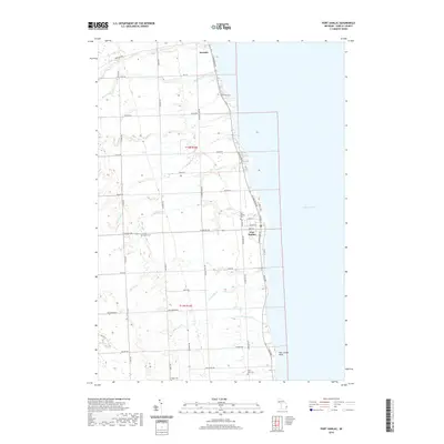
2019 Map of Port Sanilac
USGS Topo · Published 2019About this map
Port Sanilac and the township of Forester occupy this stretch of the Michigan shoreline, where the agricultural interior meets the expansive waters of Lake Huron. The landscape is defined by a series of parallel creeks—including McKenzie Creek, Herron Creek, and Forester Creek—that drain eastward through the fertile plains of Sanilac County. These waterways carved the small ravines that shaped early settlement patterns and road placements, such as Lakeshore Road and North Ridge Road. Local history and genealogy researchers will find several notable burial grounds documented, including Port Sanilac Cemetery, Ridge Cemetery, and Saint Marys Cemetery near East Sanilac Road. The map also records coastal landmarks like New London Point, illustrating the long-standing relationship between the community and the Great Lakes maritime environment.
Find a feature on this map
51 named features on this map. Tap any name to fly to it.
Don’t see what you’re looking for? This feature index may not catch every label — zoom into the map to look around manually.
Map Details
Editions of this 2019 Port Sanilac Map
This is the sole edition of this map. No revisions or reprints were ever made.
Other maps of this area

1954 · Flint
USGS Topo · 1:250,000

1958 · Flint
USGS Topo · 1:250,000

1963 · Croswell
USGS Topo · 1:24,000

1963 · Port Sanilac
USGS Topo · 1:24,000

1963 · Applegate
USGS Topo · 1:24,000

1963 · Deckerville
USGS Topo · 1:24,000

1963 · Richmondville
USGS Topo · 1:24,000
1963 · Carsonville
USGS Topo · 1:24,000

1984 · Harbor Beach
USGS Topo · 1:100,000

1984 · Croswell
USGS Topo · 1:100,000