1982 Map of Port St. Joe
USGS Topo · Published 1983About this map
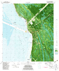
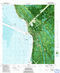
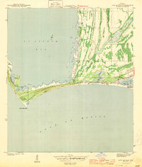
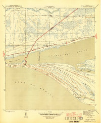
Port St Joe serves as the industrial and civic heart of this Gulf Coast landscape, shown here at a moment when its identity as the site of Florida's first constitutional convention is preserved at the Constitution Convention State Museum. The town's grid is bounded by St Joseph Bay to the west and the expansive George Washington Swamp to the east. Infrastructure such as the Gulf County Canal and a prominent Drawbridge at Highland View facilitate maritime commerce, while the Old Railroad Grade and Rifle Range point to older layers of land use.
Find a feature on this map
40 named features on this map. Tap any name to fly to it.
Don’t see what you’re looking for? This feature index may not catch every label — zoom into the map to look around manually.
Map Details
Editions of this 1982 Port St. Joe Map
2 editions found
Other maps of this area
1943 · St Joseph Spit
USGS Topo · 1:31,680
1943 · Port St. Joe
USGS Topo · 1:31,680
1943 · Cape San Blas
USGS Topo · 1:31,680
1943 · Overstreet
USGS Topo · 1:31,680

1943 · Indian Pass
USGS Topo · 1:24,000
1944 · Beacon Hill
USGS Topo · 1:31,680

1944 · White City
USGS Topo · 1:24,000
1945 · Lake Wimico
USGS Topo · 1:31,680

1945 · White City
USGS Topo · 1:31,680
1945 · Indian Pass
USGS Topo · 1:31,680