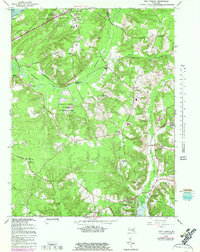
1966 Map of Port Tobacco
USGS Topo · Published 1983About this map
The Port Tobacco River valley in Charles County preserves a landscape of deep historical significance, notably featuring the site of Habre de Venture and Rose Hill. This mid-century survey captures the region as the Government Railroad and its various sidings, such as Bennsville Siding and Pomfret Siding, serviced the rural interior. The map documents a transition from traditional agricultural land to modern utility, seen in the proximity of Maryland Airport to established religious sites like St Johns Chapel and Metropolitan Ch. Conservation efforts are anchored by the Myrtle Grove Wildlife Management Area, while the emerging educational landscape is marked by the Charles County Community College. Settlement patterns follow the old transit routes, including Stagecoach Road and Poorhouse Road, connecting small communities like Mason Springs and McConchie to the Potomac River at Chapman Landing.
Find a feature on this map
58 named features on this map. Tap any name to fly to it.
Don’t see what you’re looking for? This feature index may not catch every label — zoom into the map to look around manually.
Map Details
Editions of this 1966 Port Tobacco Map
4 editions found
Other maps of this area

1889 · Fredericksburg
USGS Topo · 1:125,000

1890 · Mt. Vernon
USGS Topo · 1:125,000

1891 · Mt. Vernon
USGS Topo · 1:125,000

1892 · Fredericksburg
USGS Topo · 1:125,000

1892 · Brandywine
USGS Topo · 1:62,500

1894 · Wicomico
USGS Topo · 1:62,500

1894 · Fredericksburg
USGS Topo · 1:125,000

1894 · Mt. Vernon
USGS Topo · 1:125,000

1895 · Wicomico
USGS Topo · 1:62,500

1895 · Brandywine
USGS Topo · 1:62,500