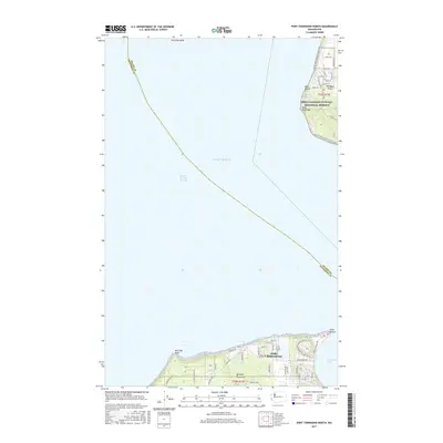
2017 Map of Port Townsend North
USGS Topo · Published 2017About this map
Port Townsend and the northern tip of the Quimper Peninsula anchor this 2017 study of the maritime landscape where the Strait of Juan de Fuca meets the Admiralty Inlet. To the north across Puget Sound, the map details the rugged western shoreline of Whidbey Island, including the protected landscapes of Ebey's Landing National Historical Reserve. This area features significant coastal landmarks like Point Partridge and Lake Pondilla, while the southern portion reveals the residential expansion of Port Townsend near Point Wilson. Researchers will find a mix of modern infrastructure and preserved nature, with the Pacific NW National Scenic Trail winding through both islands. Inland water bodies such as Tibbals Lake and the coastal shelf of Partridge Bank provide insight into the diverse hydrography of the region.
Find a feature on this map
60 named features on this map. Tap any name to fly to it.
Don’t see what you’re looking for? This feature index may not catch every label — zoom into the map to look around manually.
Map Details
Editions of this 2017 Port Townsend North Map
This is the sole edition of this map. No revisions or reprints were ever made.
Other maps of this area

1939 · Port Townsend
USGS Topo · 1:62,500

1939 · Coupeville
USGS Topo · 1:62,500

1943 · Richardson
USGS Topo · 1:62,500

1943 · Deception Pass
USGS Topo · 1:62,500

1951 · Deception Pass
USGS Topo · 1:62,500

1953 · Coupeville
USGS Topo · 1:24,000

1953 · Nordland
USGS Topo · 1:24,000

1953 · Port Townsend North
USGS Topo · 1:24,000
1953 · Port Townsend South
USGS Topo · 1:24,000
1953 · Gardiner
USGS Topo · 1:24,000