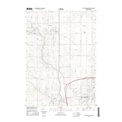
2016 Map of Port Washington West
USGS Topo · Published 2016About this map
The Milwaukee River winds through the heart of Ozaukee County, anchoring a series of historic riverside communities including Saukville, Waubeka, and Fredonia. This survey captures the rural-to-suburban character of the region as it appeared in the mid-2010s, showing the transition from the dense street grids of Port Washington to the expansive natural terrain of the Cedarburg Bog and Long Lake.
Find a feature on this map
121 named features on this map. Tap any name to fly to it.
Don’t see what you’re looking for? This feature index may not catch every label — zoom into the map to look around manually.
Map Details
Editions of this 2016 Port Washington West Map
This is the sole edition of this map. No revisions or reprints were ever made.
Other maps of this area

1892 · Port Washington
USGS Topo · 1:62,500

1904 · West Bend
USGS Topo · 1:62,500

1904 · Port Washington
USGS Topo · 1:62,500

1954 · Sheboygan Falls
USGS Topo · 1:62,500

1954 · Milwaukee
USGS Topo · 1:250,000

1955 · Kewaskum
USGS Topo · 1:62,500

1957 · Madison
USGS Topo · 1:250,000

1958 · Milwaukee
USGS Topo · 1:250,000
1958 · Port Washington East
USGS Topo · 1:24,000

1959 · Port Washington West
USGS Topo · 1:24,000