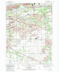
1992 Map of Portage
USGS Topo · Published 1992About this map
Indiana Dunes National Lakeshore dominates the northern shoreline, where the landscape transitions from the waters of Lake Michigan into a complex network of industrial and natural features. This 1990s revision documents the growth of Portage and South Haven, showing the intensive rail and road infrastructure necessary for the region's shipping and manufacturing economy. The Indiana Toll Road and major rail lines like Conrail and the Elgin Joliet and Eastern Ry cut through the terrain, intersecting with Burns Ditch and the Little Calumet River. Local history is preserved in the location of numerous burial grounds, including Calvary Cemetery, McCool Cem, and James Cem. Residential pockets like Garyton, Crisman, and Willow Creek are shown amidst expanding institutional landmarks such as Portage High Sch and the Porter Memorial Hosp.
Find a feature on this map
79 named features on this map. Tap any name to fly to it.
Don’t see what you’re looking for? This feature index may not catch every label — zoom into the map to look around manually.
Map Details
Editions of this 1992 Portage Map
This is the sole edition of this map. No revisions or reprints were ever made.
Other maps of this area

1900 · Toleston
USGS Topo · 1:62,500

1934 · Porter
USGS Topo · 1:48,000

1940 · Porter
USGS Topo · 1:62,500

1953 · Palmer
USGS Topo · 1:24,000

1953 · Gary
USGS Topo · 1:24,000

1953 · Crown Point
USGS Topo · 1:24,000

1953 · Garyton
USGS Topo · 1:24,000

1953 · Valparaiso
USGS Topo · 1:24,000

1953 · Ogden Dunes
USGS Topo · 1:24,000

1953 · Chesterton
USGS Topo · 1:24,000