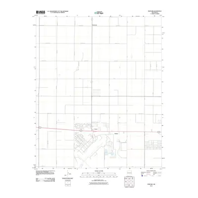
2010 Map of Portair
USGS Topo · Published 2010About this map
Portair serves as a focal point in this high plains landscape of Curry County, dominated by the expansive footprint of the Cannon Air Force Base in the southern sector. The map illustrates a highly organized section-line road system characteristic of eastern New Mexico, where routes like County Rd 16 and Curry Road 16 define a grid of agricultural and military utility. Small settlements such as Ranchvale and Gallaher are spaced across the northern and central areas, reflecting the regional pattern of scattered residential clusters amidst wide-open spaces. The presence of the base introduces a complex network of internal runways and specialized infrastructure that contrasts sharply with the surrounding rural landscape. Local historians and genealogists may find value in the specific naming of rural thoroughfares like Kelli Rd and Katy Rd, which provide precise locations for family homes and farmstead properties at the start of the 2010s.
Find a feature on this map
30 named features on this map. Tap any name to fly to it.
Don’t see what you’re looking for? This feature index may not catch every label — zoom into the map to look around manually.
Map Details
Editions of this 2010 Portair Map
This is the sole edition of this map. No revisions or reprints were ever made.
Other maps of this area

1954 · Clovis
USGS Topo · 1:250,000

1957 · Portair
USGS Topo · 1:62,500

1957 · Clovis
USGS Topo · 1:62,500

1957 · Pleasant Hill
USGS Topo · 1:62,500

1957 · Hammond Ranch
USGS Topo · 1:62,500

1958 · Clovis
USGS Topo · 1:250,000

1985 · Portair
USGS Topo · 1:24,000

1985 · Midway
USGS Topo · 1:24,000
1985 · Garrett Ranch
USGS Topo · 1:24,000
1985 · Hammond Ranch SW
USGS Topo · 1:24,000