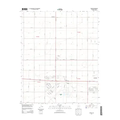
2013 Map of Portair
USGS Topo · Published 2013About this map
Cannon AFB and the western edge of Clovis anchor this modern survey of the High Plains in Curry County. The landscape is defined by the strict rectilinear grid of the Public Land Survey System, with numbered county roads like Co Road 12 and Co Road 16 partitioning the terrain into mile-square sections. The influence of the military installation is evident in the specialized street names near the base, including Terminal Ave and Overlord Blvd, while the agricultural character of the region persists at the Rajen Dairy. Small rural hubs such as Portair and Gallaher sit along the major transportation corridor of Us-60 84, which facilitates movement through the expansive Llano Estacado. To the north, the settlement of Ranchvale marks a quiet crossing of State Route 311, illustrating the area's transition from open range to a organized rural and military landscape.
Find a feature on this map
74 named features on this map. Tap any name to fly to it.
Don’t see what you’re looking for? This feature index may not catch every label — zoom into the map to look around manually.
Map Details
Editions of this 2013 Portair Map
This is the sole edition of this map. No revisions or reprints were ever made.
Other maps of this area

1954 · Clovis
USGS Topo · 1:250,000

1957 · Portair
USGS Topo · 1:62,500

1957 · Clovis
USGS Topo · 1:62,500

1957 · Pleasant Hill
USGS Topo · 1:62,500

1957 · Hammond Ranch
USGS Topo · 1:62,500

1958 · Clovis
USGS Topo · 1:250,000

1985 · Portair
USGS Topo · 1:24,000

1985 · Midway
USGS Topo · 1:24,000
1985 · Garrett Ranch
USGS Topo · 1:24,000
1985 · Hammond Ranch SW
USGS Topo · 1:24,000