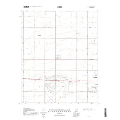
2020 Map of Portair
USGS Topo · Published 2020About this map
Cannon Air Force Base dominates the southern landscape of this Curry County region, with the expansive airfield and base infrastructure of Cannon AFB positioned just west of the city limits. This portion of the High Plains illustrates a transition from the structured residential grid of western Clovis to the vast, irrigated agricultural tracts defined by a rigid network of section roads like W Llano Estacado Blvd and Curry Road 13. The small settlements of Portair and Gallaher sit near the base and railroad corridors, while Ranchvale marks a quiet northern outpost. This map documents a high-desert environment where military aviation and large-scale ranching intersect at the edge of one of New Mexico's most significant plains communities.
Find a feature on this map
76 named features on this map. Tap any name to fly to it.
Don’t see what you’re looking for? This feature index may not catch every label — zoom into the map to look around manually.
Map Details
Editions of this 2020 Portair Map
This is the sole edition of this map. No revisions or reprints were ever made.
Other maps of this area

1954 · Clovis
USGS Topo · 1:250,000

1957 · Portair
USGS Topo · 1:62,500

1957 · Clovis
USGS Topo · 1:62,500

1957 · Pleasant Hill
USGS Topo · 1:62,500

1957 · Hammond Ranch
USGS Topo · 1:62,500

1958 · Clovis
USGS Topo · 1:250,000

1985 · Portair
USGS Topo · 1:24,000

1985 · Midway
USGS Topo · 1:24,000
1985 · Garrett Ranch
USGS Topo · 1:24,000
1985 · Hammond Ranch SW
USGS Topo · 1:24,000