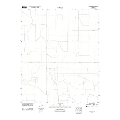
2010 Map of Portair SW
USGS Topo · Published 2010About this map
The High Plains of Eastern New Mexico are defined here by a rigid geometric grid of agricultural thoroughfares during the first decade of the 21st century. Running through the heart of the landscape, Curry Road 3 and Curry Road 4 serve as primary lateral arteries for the region's ranching and farming operations. The map documents the precise jurisdictional boundary where the naming conventions shift between the northern and southern halves of the quadrangle. In the northern reaches, names like Curry Road Y and Curry Road U dominate, while the southern section transitions to the Roosevelt County numbering system, including S Roosevelt Road X and S Roosevelt Road Ab. This intersection of road networks highlights the coordinated surveying efforts required to manage the vast, open acreage typical of this portion of the Llano Estacado.
Find a feature on this map
13 named features on this map. Tap any name to fly to it.
Don’t see what you’re looking for? This feature index may not catch every label — zoom into the map to look around manually.
Map Details
Editions of this 2010 Portair SW Map
This is the sole edition of this map. No revisions or reprints were ever made.
Other maps of this area

1954 · Clovis
USGS Topo · 1:250,000

1957 · Portair
USGS Topo · 1:62,500

1957 · Melrose
USGS Topo · 1:62,500

1957 · Portales
USGS Topo · 1:62,500

1958 · Clovis
USGS Topo · 1:250,000

1972 · Melrose East
USGS Topo · 1:24,000

1973 · Floyd
USGS Topo · 1:24,000
1973 · Melrose SE
USGS Topo · 1:24,000

1985 · Portair
USGS Topo · 1:24,000
1985 · Portales
USGS Topo · 1:24,000