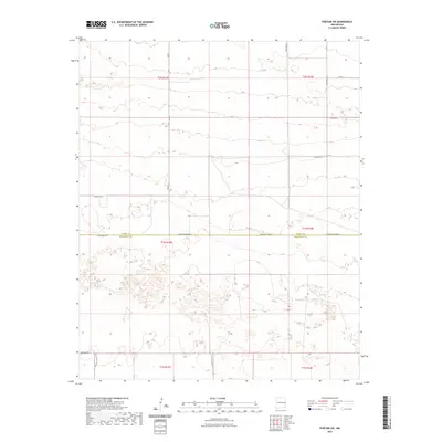
2023 Map of Portair SW
USGS Topo · Published 2023About this map
The county line between Curry Co and Roosevelt Co bisects this High Plains landscape, where the Jeffersonian grid of the Public Land Survey System dictates the modern road network. This survey illustrates a strictly organized agricultural geography, defined by long straightaways such as Baseline Rd and N Roosevelt Road 3. The terrain is characterized by subtle topographic depressions and playas typical of this region, providing a look at the drainage patterns that influence local land use. Local transport is facilitated by a dense network of numbered and lettered routes, including Curry Road V and S Roosevelt Rd 40, which connect the rural sections of t1n r33e and t2n r34e.
Find a feature on this map
18 named features on this map. Tap any name to fly to it.
Don’t see what you’re looking for? This feature index may not catch every label — zoom into the map to look around manually.
Map Details
Editions of this 2023 Portair SW Map
This is the sole edition of this map. No revisions or reprints were ever made.
Other maps of this area

1954 · Clovis
USGS Topo · 1:250,000

1957 · Portair
USGS Topo · 1:62,500

1957 · Melrose
USGS Topo · 1:62,500

1957 · Portales
USGS Topo · 1:62,500

1958 · Clovis
USGS Topo · 1:250,000

1972 · Melrose East
USGS Topo · 1:24,000

1973 · Floyd
USGS Topo · 1:24,000
1973 · Melrose SE
USGS Topo · 1:24,000

1985 · Portair
USGS Topo · 1:24,000
1985 · Portales
USGS Topo · 1:24,000