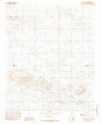
1985 Map of Portair SW
USGS Topo · Published 1985About this map
The Curry Co Roosevelt Co boundary bisects this high plains landscape, documenting a sparsely populated region of New Mexico during the mid-1980s. The survey focuses on the infrastructure of land management and resource extraction, prominently featuring the east-west Base Line that serves as a fundamental surveying reference for the territory. The terrain is defined by its agricultural and industrial utility rather than settlement, with numerous Well and Wells sites scattered across the quadrangle to support local needs. Small-scale industrial activity is evidenced by several Gravel Pit locations, which punctuate the landscape and indicate local quarrying efforts. This provisional study by the Geological Survey captures the quiet, utilitarian character of the Llano Estacado region before further modern developments altered these rural county lines.
Find a feature on this map
5 named features on this map. Tap any name to fly to it.
Don’t see what you’re looking for? This feature index may not catch every label — zoom into the map to look around manually.
Map Details
Editions of this 1985 Portair SW Map
This is the sole edition of this map. No revisions or reprints were ever made.
Other maps of this area

1954 · Clovis
USGS Topo · 1:250,000

1957 · Portair
USGS Topo · 1:62,500

1957 · Melrose
USGS Topo · 1:62,500

1957 · Portales
USGS Topo · 1:62,500

1958 · Clovis
USGS Topo · 1:250,000

1972 · Melrose East
USGS Topo · 1:24,000

1973 · Floyd
USGS Topo · 1:24,000
1973 · Melrose SE
USGS Topo · 1:24,000

1985 · Portair
USGS Topo · 1:24,000
1985 · Portales
USGS Topo · 1:24,000