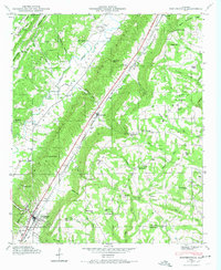
1946 Map of Portersville
USGS Topo · Published 1974About this map
Big Wills Valley serves as the primary corridor for commerce and travel through this part of De Kalb County in 1946, with the Southern railroad and US Route 11 cutting a straight path through the heart of the landscape. The settlement of Collinsville anchors the southern portion of the sheet near a large Reservoir, while Portersville sits at a critical gap in the ridges to the north. These valley communities are surrounded by a dense network of family-centered landmarks, including several schools and churches such as Graham Chapel and the McNutt Memorial Ch.
Find a feature on this map
73 named features on this map. Tap any name to fly to it.
Don’t see what you’re looking for? This feature index may not catch every label — zoom into the map to look around manually.
Map Details
Editions of this 1946 Portersville Map
2 editions found
Other maps of this area

1893 · Fort Payne
USGS Topo · 1:125,000

1898 · Fort Payne
USGS Topo · 1:125,000

1900 · Fort Payne
USGS Topo · 1:125,000

1936 · Crossville
USGS Topo · 1:24,000

1936 · Roden Gap
USGS Topo · 1:24,000

1936 · Chavies
USGS Topo · 1:24,000
1936 · Fyffe
USGS Topo · 1:24,000

1946 · Portersville
USGS Topo · 1:24,000

1946 · Ft Payne
USGS Topo · 1:24,000
1946 · Chavies
USGS Topo · 1:24,000