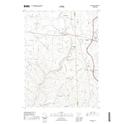
2019 Map of Portersville
USGS Topo · Published 2019About this map
Slippery Rock Creek Gorge dominates the central landscape of this western Pennsylvania region, where the water cuts deeply through the terrain as it flows toward the confluence of Skunk Run and Hell Run. The area's industrial and agricultural history is anchored by early mill sites such as Kennedy Mill and McConnells Mill, while the eastern portion of the map transition to the recreational waters of Lake Arthur and its many coves. This modern survey illustrates the persistent importance of local congregations, preserving the locations of numerous historic church grounds and burial sites including the Portersville Bible Church Cem and the Mountville Presbyterian Church Cem. The coexistence of the N Country National Scenic Trail and the Pleasant Hill Airport reflects a landscape that serves both backcountry hikers and local aviation in the corridor between Princeton and Portersville.
Find a feature on this map
149 named features on this map. Tap any name to fly to it.
Don’t see what you’re looking for? This feature index may not catch every label — zoom into the map to look around manually.
Map Details
Editions of this 2019 Portersville Map
This is the sole edition of this map. No revisions or reprints were ever made.
Other maps of this area

1902 · New Castle
USGS Topo · 1:62,500

1904 · Newcastle
USGS Topo · 1:62,500

1905 · Neshannock
USGS Topo · 1:62,500

1907 · Neshannock
USGS Topo · 1:62,500

1908 · Zelienople
USGS Topo · 1:62,500

1910 · Zelienople
USGS Topo · 1:62,500

1913 · Mercer
USGS Topo · 1:62,500

1939 · Mercer
USGS Topo · 1:62,500

1943 · Mercer
USGS Topo · 1:62,500

1950 · Cleveland
USGS Topo · 1:250,000
Featured Places
- Portersville, PA
- Wayne Township, PA
- Princeton, Slippery Rock Township
- Rose Point, Slippery Rock Township
- Worth Township, PA