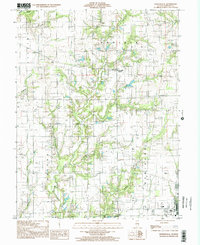
1998 Map of Porterville
USGS Topo · Published 2002About this map
Porterville (Eaton) serves as the primary settlement in this late 20th-century survey of Crawford County, Illinois. The landscape is heavily marked by the region's energy economy, with numerous Oil Fields and a prominent Pipe Line stretching across the Prairie terrain. An important historical landmark, the Indian Treaty Boundary, cuts through the southeastern corner of the map, providing a glimpse into early American land partitions.
Find a feature on this map
21 named features on this map. Tap any name to fly to it.
Don’t see what you’re looking for? This feature index may not catch every label — zoom into the map to look around manually.
Map Details
Editions of this 1998 Porterville Map
This is the sole edition of this map. No revisions or reprints were ever made.
Other maps of this area

1910 · Hardinville
USGS Topo · 1:62,500

1917 · Birds
USGS Topo · 1:62,500

1942 · Birds
USGS Topo · 1:62,500

1953 · Indianapolis
USGS Topo · 1:250,000

1956 · Indianapolis
USGS Topo · 1:250,000

1956 · Annapolis
USGS Topo · 1:62,500

1956 · Vincennes
USGS Topo · 1:250,000

1957 · Indianapolis
USGS Topo · 1:250,000

1957 · Vincennes
USGS Topo · 1:250,000

1957 · Hutsonville
USGS Topo · 1:62,500