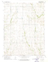
1973 Map of Portis NW
USGS Topo · Published 1975About this map
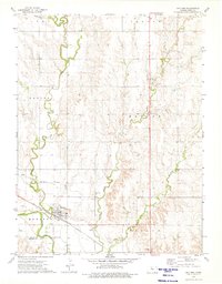
Crystal Plains defines the central landscape of this Smith County survey, where the prairie is dissected by a network of drainage systems. The convergence of the West Branch Twelvemile Creek and East Branch Twelvemile Creek in the southern portion of the map illustrates the local hydrology that shaped early settlement patterns. This agricultural region is dotted with several small community focal points, including the Crystal Plains Ch and multiple family or community burial grounds such as Custer Cem and Bell Cem. To the north, Monkey Run and West Oak Creek flow through the townships of Center and Blaine, while evidence of local industry appears in the form of several Quarry sites located near the creek bluffs. The grid of section lines and the distribution of farmsteads reveal a settled landscape established during the homesteading era and maintained through the late twentieth century.
Find a feature on this map
16 named features on this map. Tap any name to fly to it.
Don’t see what you’re looking for? This feature index may not catch every label — zoom into the map to look around manually.
Map Details
Editions of this 1973 Portis NW Map
This is the sole edition of this map. No revisions or reprints were ever made.
Other maps of this area

1893 · Smith Center
USGS Topo · 1:125,000

1955 · Beloit
USGS Topo · 1:250,000

1959 · Beloit
USGS Topo · 1:250,000

1960 · Downs North
USGS Topo · 1:24,000

1961 · Portis
USGS Topo · 1:24,000

1961 · Harlan
USGS Topo · 1:24,000
1973 · Portis NE
USGS Topo · 1:24,000
1973 · Smith Center
USGS Topo · 1:24,000
1973 · Lebanon
USGS Topo · 1:24,000
1973 · Gaylord
USGS Topo · 1:24,000