
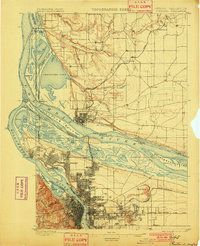
1897 Map of Portland
USGS Topo · Published 1897About this map
The Portland and Vancouver urban centers dominate this late-19th-century survey, revealing the intricate geography of the Columbia-Willamette confluence before the landscape was heavily reshaped by modern industry. The map illustrates a dense network of river commerce and rail lines, including the Northern Pacific Railroad and the Oregon Railroad and Navigation Co., which converged to serve the growing regional economy. On the Washington side, the Vancouver Barracks stands as a prominent military presence overlooking the Columbia River.
Find a feature on this map
69 named features on this map. Tap any name to fly to it.
Don’t see what you’re looking for? This feature index may not catch every label — zoom into the map to look around manually.
Map Details
Editions of this 1897 Portland Map
2 editions found
Other maps of this area

1905 · Portland
USGS Topo · 1:62,500

1911 · Boring
USGS Topo · 1:48,000

1914 · Boring
USGS Topo · 1:62,500

1914 · Oregon City
USGS Topo · 1:62,500

1915 · Hillsboro
USGS Topo · 1:62,500

1916 · Tualatin
USGS Topo · 1:62,500

1916 · Estacada
USGS Topo · 1:125,000

1918 · Hillsboro
USGS Topo · 1:62,500

1918 · Troutdale
USGS Topo · 1:62,500

1922 · St. Helens
USGS Topo · 1:62,500