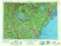
1956 Map of Portland
USGS Topo · Published 1969About this map
The White Mountains and the rugged Maine-New Hampshire coast dominate this 1950s-era regional survey. Anchored by the peak of Mt Washington, the landscape transitions from the high elevations of the White Mountain National Forest down to the sprawling waters of Lake Winnipesaukee and Sebago Lake. The map details a post-war infrastructure, including the early development of Pease AFB near Portsmouth and the extensive rail networks of the Boston and Maine and Canadian National railroads. Along the Atlantic Ocean, the map traces the shoreline from Portland through famous summer colonies like Old Orchard Beach and Kennebunkport. It provides a comprehensive view of the industrial and recreational corridor connecting the New Hampshire state capital of Concord and the mill city of Manchester to the coastal ports.
Find a feature on this map
150 named features on this map. Tap any name to fly to it.
Don’t see what you’re looking for? This feature index may not catch every label — zoom into the map to look around manually.
Map Details
Editions of this 1956 Portland Map
4 editions found

Other maps of this area

1888 · Newburyport
USGS Topo · 1:62,500

1888 · Haverhill
USGS Topo · 1:62,500

1890 · Haverhill
USGS Topo · 1:62,500

1890 · Newburyport
USGS Topo · 1:62,500

1891 · Portland
USGS Topo · 1:62,500

1891 · Biddeford
USGS Topo · 1:62,500

1891 · Berwick
USGS Topo · 1:62,500

1891 · Kennebunk
USGS Topo · 1:62,500

1891 · Buxton
USGS Topo · 1:62,500

1891 · Newfield
USGS Topo · 1:62,500