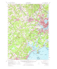
1957 Map of Portland
USGS Topo · Published 1967About this map
Portland Harbor and the surrounding coastal reaches of Saco Bay anchor this mid-century survey, illustrating a period of significant growth along the Maine coast. The urban core of Portland and South Portland is densely detailed, showing the industrial infrastructure of the Portland Terminal Company and Canadian National Railway alongside established residential neighborhoods like Rosemont and Libbytown. The transition from the commercial waterfront to the seasonal resort character of Old Orchard Beach and Prouts Neck reflects the diverse economy of the era, where maritime trade met burgeoning coastal tourism.
Find a feature on this map
117 named features on this map. Tap any name to fly to it.
Don’t see what you’re looking for? This feature index may not catch every label — zoom into the map to look around manually.
Map Details
Editions of this 1957 Portland Map
3 editions found
Other maps of this area

1891 · Portland
USGS Topo · 1:62,500

1891 · Biddeford
USGS Topo · 1:62,500

1891 · Kennebunk
USGS Topo · 1:62,500

1891 · Buxton
USGS Topo · 1:62,500

1892 · Freeport
USGS Topo · 1:62,500

1892 · Buxton
USGS Topo · 1:62,500

1893 · Kennebunk
USGS Topo · 1:62,500

1893 · Biddeford
USGS Topo · 1:62,500

1893 · Portland
USGS Topo · 1:62,500

1893 · Casco Bay
USGS Topo · 1:62,500